Aquaveo & Water Resources Engineering News

Training Mexico City, Mexico

A GMS training course was held from March 5-8 in Mexico City, Mexico. Alan Lemon of the GMS development team and Dr. Willis Weight of Carroll College, Montana taught the course.

The course was well attended. More than 20 people attended the course. There was a wide variety in the amount of experience with groundwater modeling. Some attendees had been building models for years, while others were relatively new to groundwater modeling. Also, the attendees came from many different backgrounds including: professors at universities, consultants, and students. Based on the comments submitted after the course, the attendees felt like they all learned something valuable that they could use in their work. Many attendees commented on how much easier it was to build models using GMS than other MODFLOW preprocessors. They appreciated using the conceptual model approach and having their data independent of a MODFLOW grid.

Thanks to Jorge Chipres and Catalina Morato for their efforts in organizing the course.
Exporting 3D Grids to Shapefiles

In GMS 8.2 we added the ability to export a 3D grid to a shapefile. All layers of the grid are exported, along with the active data set and the grid cell activity (IBOUND) and data set activity (dry cells) if they exist. Here is the list of the attributes that get exported:
  • cell ID
  • cell I
  • cell J
  • cell K
  • grid cell activity
  • active scalar data set values
  • active data set activity (if it exists)
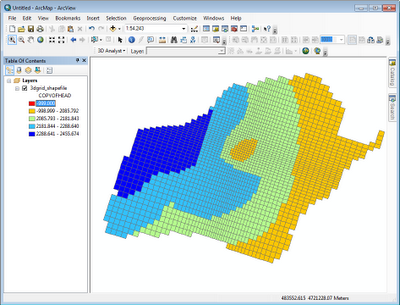
A simple definition query using the grid cell activity and K fields can be created in ArcMap to see one layer of the grid at a time. For example, the following figure shows the head solution on the third layer of the grid from the lake package tutorial as a shapefile in ArcMap.


MODFLOW-NWT Interface

With the release this week of GMS 8.2, GMS includes support for MODFLOW-NWT including the UPW package and NWT solver. Compiled versions of the MODFLOW-NWT executable are included with the GMS installer, including versions for 64 bit and double precision. A new tutorial covering the NWT interface has been added and is included in the tutorial installer and is also available via the learning center.


February 2012 Sprint Highlights

Some of the more interesting accomplishments from the February 2012 sprint:
  • Released GMS 8.2
  • Finished GMS 8.3 beta
  • Flow vector calculations are now velocity vectors
  • Design for MODFLOW-CDSS
  • Gage package progress
  • PEST Null space Monte Carlo progress
  • Fixed over 36 bugs
  • Created GUI tests for the MNW2 package, FEMWATER transport tutorial, Map -> 3D scatter, 2D Scatter -> 3D Scatter and other features
  • Progress on MODFLOW-LGR design
  • MT3D heat transport tutorial
  • Documented versions of third party software on the wiki

January 2012 Sprint Highlights

Some of the more interesting accomplishments from the January 2012 sprint: 
  • Fixed over 18 bugs
  • Finished 8.3 installer and separated tutorials from main program
  • Created two new videos on our YouTube channel
  • Finished about 99% of our continuous integration system
  • Finished MODFLOW MNW2 package interface
  • Updated MODFLOW NWT to the latest version
  • Implemented tech support notifications for the new "Report A Bug" feature
  • Added support for MT3D steady state stress periods
  • Overhauled the CCF -> Vectors feature to actually give velocity vectors (long overdue). Pushed it to GMS 8.2.
  • Created some more SEAWAT tutorials
  • Started on creating more MNW2 tutorials
  • Hooked up the dialog help buttons to the CHM file.
  • Found and fixed some memory looks.
  • Designed the interface for the MODFLOW SUB Package
  • Added MODPATH starting locations -> 3D scatter and vice versa
  • Added Shapefile -> 3D Scatter and vice versa
  • Added some SEEP2D images to the Image Gallery
  • Got the intermediate tests passing for Visual Studio 2010
  • Made the Community Edition work without a license


ZONEBUDGET in GMS


GMS has an extensive tool set for working with flow budget information from MODFLOW. GMS is the only package that reports flow budget information on GIS features. For example, if polylines or polygons were used to create drain boundary conditions in MODFLOW then GMS will report the flow into or out of the model from the polyline/polygon. For some time now, GMS has allowed users to view flow budgets for selected sub-areas of their models as well as the ability to assign zone budget ids to cells and extract flow budget information.

Beginning with GMS 8.2, we will now include an interface to USGS ZONEBUDGET. This tool is accessed by selecting the Flow Budget menu command in the MODFLOW menu. There is a USGS ZONEBUDGET tab available in the dialog. The user can set up their input options and then there is a button to launch ZONEBUDGET. The input and output files for ZONEBUDGET are written to the same directory where the MODFLOW Cell-to-cell flow file is located.

There is also a new tutorial available that shows the various ZONEBUDGET options. Go to the GMS Learning Center on http://www.aquaveo.com/gms-learning to download the tutorial.

A video that demos the ZONEBUDGET feature is available on the Aquaveo youtube channel.

December 2011 Sprint Highlights

Some of the more interesting accomplishments from the December 2011 sprint:

  • Fixed over 14 bugs
  • Finished 8.2 installer
  • Greatly improved the MODFLOW water table display in side view and got it working with MODFLOW-NWT solutions
  • Posted the first beta of GMS 8.2
  • Finished about 80% of our continuous integration system
  • Finished about 80% of the MODFLOW MNW2 package interface
  • Created an initial chm help file from the wiki. Doc-To-Help has a couple of blog posts about it
  • Created initial support for opening the chm help file to a particular topic from a dialog
  • Implemented a user request to change the MODPATH pathline color as it passes through different zones
  • Added a "Report a Bug" command to the Help menu
  • Added some user testimonials to aquaveo.com

November 2011 Sprint Highlights

Some of the more interesting accomplishments from the November 2011 sprint:
  • Fixed over 5 bugs
  • Updated the tutorials for 8.2
  • Designed and implemented the ZONEBUDGET interface (available in 8.2)
  • Added registration components for MODFLOW-NWT and ZONEBUDGET
  • Created GUI tests for MODFLOW-NWT and ZONEBUDGET
  • Branched 8.2
  • Created the online license manager for 8.2
  • Created an automated nightly build that's posted and available at aquaveo.com
  • Completed about 40% of the MODFLOW MNW2 package interface
  • Designed a GSFLOW interface
  • Started designing the PEST Null space Monte Carlo interface
  • Got chapters working in wiki to ODT conversion
  • Started creating a FEMWATER transport tutorial

October 2011 Sprint Highlights

Some of the more interesting accomplishments from the October 2011 sprint (now that it's almost December):

  • Fixed 10 bugs
  • Got our version of MODFLOW-NWT working with MNW, SFR and UZF packages
  • Fixed the model wrapper for MODFLOW-NWT to show progress
  • Documented MODFLOW-NWT on the wiki
  • Created a MODFLOW-NWT tutorial
  • Held a training course in Australia (see post below)
  • Designed and implemented the ZONEBUDGET interface (available in 8.2)
  • Made some improvements to our continuous testing system, including adding a new machine
  • Added an Export 3D Grid to Shapefile feature (available in 8.2)
  • Fixed some problems with the new manual MODPATH option (available in 8.2)
  • Designed support for the ISTCB2 option in the SFR package
  • Reviewed user requests on the forum and put them on the backlog

Exporting 3D grids to shapefiles

A new feature in GMS 8.2 is the ability to export a 3D grid to a shapefile. The following figures show a MODFLOW model from the Lake package tutorial. The first image shows the model in GMS. The second shows the grid exported as a shapefile and read into ArcMap 10 with a background map, symbology, and transparency. GMS includes a projection file with the exported shapefile which causes it to be properly positioned when imported to ArcMap.


Pages